
Satellite images of Maxar also for US allies
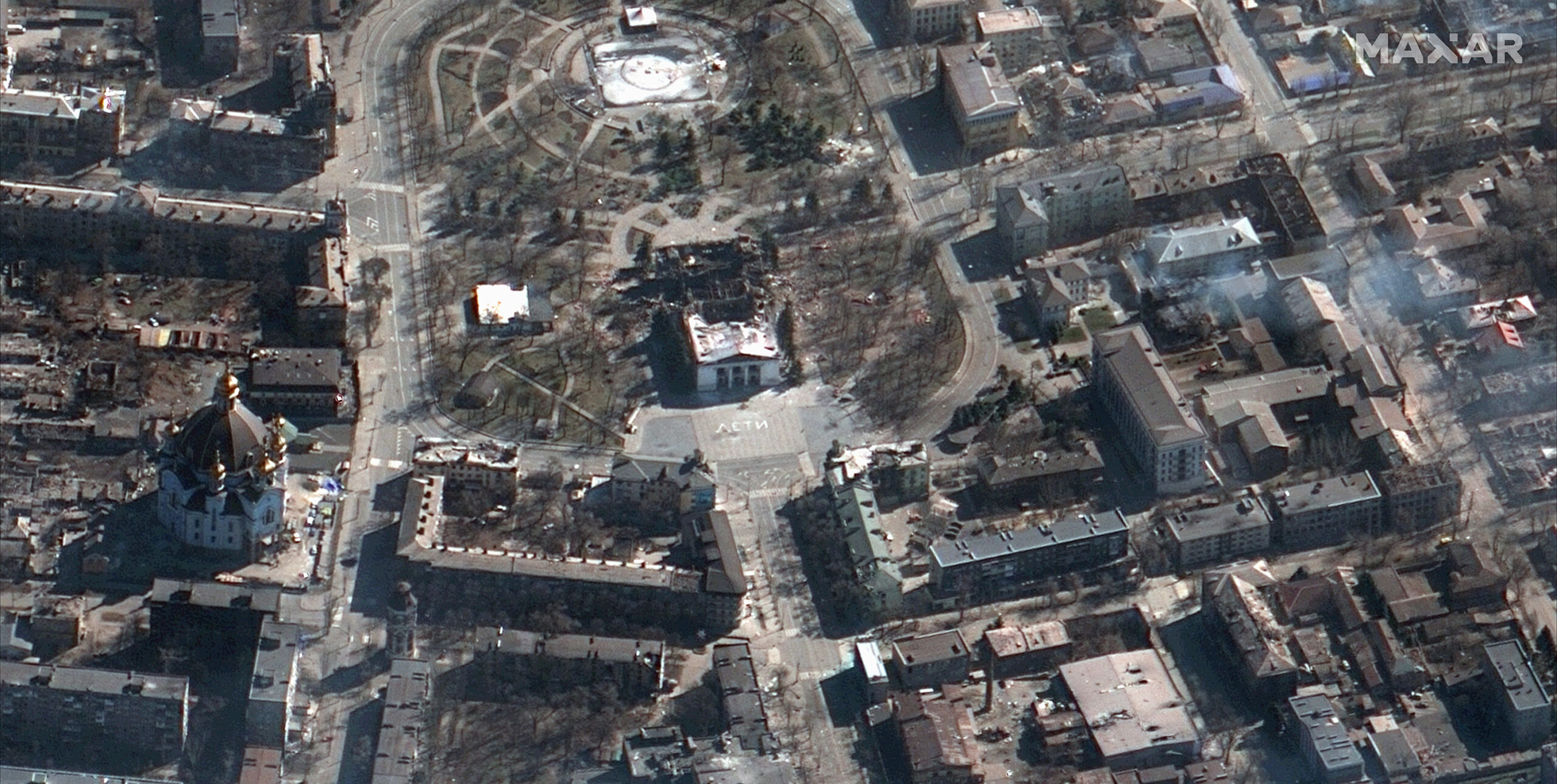
Maxar, a leading provider of commercial satellite imagery to US national security agencies, has been awarded a contract by the National Geospatial-Intelligence Agency to provide satellite imagery to US allies. The company became famous last March for its shots of Ukrainian battlefields
U.S. allies will have access to high-resolution satellite imagery and analysis from Maxar on demand.
The National Geospatial-Intelligence Agency (NGA) has awarded Maxar Technologies a five-year contract to provide commercial satellite imagery to US allies.
The contract is worth up to $192 million, the company said in a Feb. 8 regulatory filing, Defense News reported.
The company became famous for its shots of Ukrainian battlefields. While other companies' satellite images have made their way into Ukraine's press coverage, none are as ubiquitous as Maxar. According to the company, Maxar provides 90% of the "critical geospatial intelligence used by the US government for national security."
Data from commercial space imaging providers is complementing government-owned space capabilities, providing detailed insights into Russian troop movements.
In December, Maxar announced its acquisition by private equity firm Advent International for $6.4 billion. The deal is expected to close by the end of the year.
All the details.
WHAT THE NEW CONTRACT PROVIDES FOR
The contract includes high-resolution electro-optical imaging and synthetic aperture radar products, which use radar to see through clouds and in dark conditions and detect things like material properties, precise motion and elevation. Maxar will also provide three-dimensional data services.
The agency did not disclose which countries or how many are supported under this contract. Since the Russian invasion of Ukraine Nga has played a central role in coordinating the flow of commercial geospatial intelligence to Ukraine and several allied countries, SpaceNews notes.
WHAT MAXAR DOES
Headquartered in Westminster, Colorado, Maxar owns and operates 90 orbiting satellites that collect detailed images from space. Its technology is used for both defense and intelligence operations, as well as Google Maps.
Maxar's history dates back to the birth of the American commercial satellite imagery industry in the 1990s, made possible in part by President Clinton's decision to open up the sale of images to foreign entities. Five years later, a company called Space Imaging launched Ikonos. After several acquisitions and a merger, Maxar Technologies was born in Westminster, Colorado in 2017.
For nearly a decade , Maxar was the sole provider of high-resolution commercial satellite imagery to the US Department of Defense's National Reconnaissance Office, which paid Maxar $300 million a year for access to its satellites and its gigantic archive of images.
The company is also involved in NASA's Artemis return to the moon program, Reuters reports.
THE TURNOVER
The contract follows two other contracts from the National Geospatial-Intelligence Agency that Maxar announced last month. The first, a $22.5 million contract, is for the agency's Janus program and will help characterize land cover on as yet unmapped areas. In another $13.3 million deal, the company will provide an interface that Nga can use to better access its commercial image archive.
Finally, last year the company won a $3.2 billion deal with the National Reconnaissance Office to provide satellite imagery to the US government over the next 10 years.
This is a machine translation from Italian language of a post published on Start Magazine at the URL https://www.startmag.it/innovazione/maxar-immagini-satellitari-alleati-usa/ on Tue, 14 Feb 2023 06:17:22 +0000.